
 Fly In and Bike the Virginia Creeper Trial
Flying Destination: Virginia Creeper Trail
Airport: KVJI – Virginia Highlands, Abingdon, VA
Activities: 17-34 mile down hill bike trail ride
Comments: Fun easy trip for the whole family or romantic weekend for a couple
Our hope is that we’ll inspire you to take off to fun places in your aircraft. Not the usual $100 hamburger stops but fun outings that will build memories of a life time.
When a brand new DA40 XLS with Synthetic Vision arrived as my demonstrator, I decided I needed a mountain destination to try out the wonders of this new technology so I could provide you folks and my customers real life reports on the value of the new system as soon as possible. I had the perfect trip in mind… a day trip to Abingdon VA for a family bike ride on the Virginia Creeper Trail.
 If you’ve never heard of the Virginia Creeper Trail we need to get you up to speed on this unique national trail. The trail is an old rail bed starting on the top of Whitetop Mountain near Mount Roger National Recreational Area and winds its way 35 miles gently through Damascus VA on to Abingdon VA. Along the way you ride through large old growth forests, down beautiful sloping creeksides with waterfalls on to open pastures and rolling hills.
If you are not much of a bike rider, you’ll be in good company. Nothing could be easier since the grade is the perfect down hill run (read no peddling required). Most of the trail is a pack cinder two lane affair and some athletic types do actually pass you by going up hill huffing and puffing rather than enjoying the very civilized down hill run.
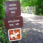
The entire area around Damascus and Abingdon is all about serving the bikers and hikers. Damascus is in fact a major refueling point for the Appalachian Trail “through hikers” that start off in Georgia in the early spring with hopes of reaching the fabled Mount Katahdin in Maine before it closes in mid October because of the extreme weather that comes by then. If you go in June or early July you’ll likely cross paths with hikers.
Let’s Fly In
So getting to this great destination is quite easy. For us it was only a 164 NM flight direct from Raleigh Durham. A quick look at typical 2 hour flight ring around KVJI places a very large group you you out there within day tripping distance for this adventure from Frederick Maryland to Norfolk, VA to Savannah Georgia to Louisville Kentucky.
On our day of departure storms where hovering along the mountain ranges to the west and we were crossing our fingers for decent weather for the day. We had clear skies all the way until 30 miles from Abingdon. Storms had crossed the mountain ridge and so we entered actual conditions at 8000 feet inbound to KVJI. The XM weather showed rain around the airport and closing in. This was perfect for checking out the new SVT in actual conditions but not ideal for bike riding. We pressed on and set up for the localizer approach for runway 24 from the north outside WHINE intersection. (an aside: what a great name for an intersection…one day I want to meet the person(s) that name all the intersections) My only complaint for VJI is they don’t have an LPV WAAS approach yet to really show off the SVT. At the rapid pace the FAA is rolling out WAAS approaches it can’t be far away.
In one way, maybe that was better, because we did not have vertical guidance so the power of the SVT really did start to shine as serious tool and comfort aid. Here we were in the clouds and rain letting down into this mountain valley with no vertical guidance other than the usual timer and the 500 feet per minute decent. What showed up of course goes beyond providing comfort. Through the scud the entire time I was looking at the white outline of the runway from 6000 feet.
It was a simple as pointing the flight marker in the SVT display on the end of the runway and watching the timer. The display of the mountains on either side was uncanny to experience while being in the clouds during the decent.
Planting the flight marker on the end of the runway gave the perfect descent angle and we popped out at 1600 feet AGL in misty rain with the runway lights in sight. As we rolled to a tie down spot, the rain really cut loose and I noticed how accurate the Nextrad radar was on the screen.
I simply can’t over stress the difference I felt using the SVT with my family on board in the weather in the mountains. I’m no airline captain or military jock with tons of flight hours. In fact the ink has hardly dried on my instrument rating so when it comes to technology like SVT I have to communicate to you guys out there that this new wrinkle makes all the difference in the world about how you are going to feel in real conditions with your important cargo aboard. I particularly like the way it allows me to relax and enjoy the process of flying the plane and the approach.
The unnerving part is how quickly my 13 year old picked up on using the Pathway boxes and the flight marker. To him its just another video game. The fact that a non-pilot of any age can pick up in minutes and fly an approach with precision means its a better mousetrap…one I’ve been dreaming of for decades.
Let’s Ride!
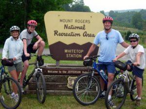
A quick call to the bike shop and they popped over to pick us up. We had made our reservations and arrangements for a pickup in advance with Virginia Creeper Trail Bike Shop located in Abingdon. We chose them because they are the closest to the airport and happy to pick up flyers. If you end up deciding to stay over in Damascus or Abingdon here is a full list of shops serving the trail.
Though the weather was bit daunting, these guys were all smiles. Within minutes we were at their well equipped shop getting fitted with our bikes, helmets and snacks. Within 15 minutes we were heading off in the van to the top of the trail. Sam, our friendly van driver, enjoyed sharing local lore and facts with us on the winding 35 mile ride. Sam grew up in Damascus so he was able to tell us the history of how the trains ended in 1977 and it was a ghost town until the bike trail came along.
Our family enjoys biking so dropping us off at Whitetop Station with a bike was like dropping tadpoles in the shallow end. The first thing you notice about the trail is how perfect the grade is. Just right! You’ll definitely use the brakes more than the peddles. This map shows the elevations and grades.
The first section of the trail takes you through beautiful old growth forest of hardwoods. I was stopping off at the trail side to show my kids what sassafras trees look like and having them rub the leaves in their hands to get that unique citrus smell they offer.
The first stop of interest on the trail is at Green Cove Station. This is a history site maintained by the Forest Service. You step inside and it is like stepping back in time. The potbelly stove is right there and you can vividly imagine the locals sitting around the stove once you’ve looked at a few of the historic photos of the place displayed around the station. The station is stocked with fun memorabilia and little items you can buy. I couldn’t pass up the Virginia Creeper Trail patches.
As you continue down the trail a creek comes along side and we were constantly looking for waterfalls and pretty little stops along the creek. Of course the farther you go the bigger the creek becomes. We enjoyed bouldering around and skipping rocks at flat bends in the creek. The next thing you notice is the wood bridges that keep popping up for you to cross. Each one offers a chance to get a different view of the creek or vista. By this time we are completely hooked on the beauty of the trail. We have to keep stopping to take pictures…its a real “film gobbler” so bring plenty of film/memory and batteries!
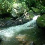


The best first “swimming hole” is between bridge 36 and 35. There are more and more as you continue on down the trail. The next major stop Tayloy’s Valley and lunch! Everything on this day was perfect and the lunch stop left nothing to bedesired. Right along the river, there it was, the Virginia Creeper Cafe! They had tons of out door seating and a cheeseburger that would make Jimmy Buffett break out into his famous chorus of a “Cheeseburger in Paradise“. All that “exercise” had built up an appetite so we loaded up with double fries and cheeseburgers “all the way”.
So when you plan to go on this great flying adventure make sure you leave the picnic behind. If you can save room for desert, the chocolate cake at the Cafe is famous…just looking at it will put extra pressure on your back tire.
With all the fun we’d had up through lunch I could have called it a day and headed home but we were only half way! All our lallygagging and over fueling at lunch had us in need of some peddle powering so we picked up the pace and enjoyed the continuous stream of gorgeous scenery and waterfalls. We’d see the occasional fly fisherman but mostly you just tool along enjoying the beauty of the stream to yourself.
Our pick up at the Damascus red caboose was scheduled for 4:30 and I really did not want this ride to end. I was wishing I’d arranged to go the full distance all the way back to Abingdon. We said many times during the day, “Wow, we have got to come back and do this again!”
The rain came again during the last half mile of our ride so we got a bit damp. No worries as we’d brought a change of clothes and got changed back at the shop. We made a quick tour of downtown Abingdon before it was time to head to the airport. The quaint nature of Abingdon had me wanting to come back just so spend some time in the little village.
This is a near perfect day trip for a family. The kids loved it. If I wanted a romantic getaway with my wife, a two night stay would be perfect. I’d fly in on Friday evening and stay in one of the many quaint bed and breakfast inns and do the whole trail on Saturday. I’d bum around Abingdon on Sunday before an easy flight home. If you want to really impress her you could stay in downtown Abingdon at the Martha Washington Inn. We did not stay over but we did enjoy a coffee on their grand front porch and even that was a treat.
We waited at the airport for a thunder bumper to pass on to the North East before leaving. This is a good point to mention my favorite pilot weather tools because they really come in handy on these type trips. If you are not already accessing weather on your cell phone in a way that works you need to check it out. My favorite is the Apple iPhone which provides easy full access to regular weather web sites like www.aviationweather.gov and specially formated sights like foreflight.com.
I’ve had my iPhone for coming up a year now and can easily say its web access ability is simply the best. The phone itself is not the greatest I’ve ever owned but for the pilot that needs access to full moving radar and easy IFR filing the iPhone wins my thumbs up over anything else I’ve seen. The ability to file flight plans in the palm of your hand and get the weather brief like you are at a computer seems like to me the perfect George Jetson compliment to the wonder of these modern glass aircraft. I encourage all pilots that plan to use their plans for traveling and especially IFR travel that they get a cell phone that supports the need.
 Once in the air the Synthetic Vision with Pathwayswas again a real treat in the mountain terrain. My son Ben wanted to hand fly the leg and I could easily see how the flight market and boxes were teaching him how to hold heading and altitude quicker than anything I’ve ever seen.
The Garmin G1000 XM weather display once again showed challenging thunderstorms and the access to this info made our flight decisions a snap for deviation around them. The extent of the info available is what is so outstanding. You not only can check the weather easily at your destination but all along the route and at alternates.
For those of you that have not experienced this level of capability in an aircraft panel I encourage you find a way to try it. During your first flight you’ll start to realize the G1000 with SVT is not just an expensive steam gauge replacement but a completely different flying experience. Some people automatically assume that with the vast capabilities of the G1000 system they would not use all that info or features. My experience has been that I use the vast majority of major features on every flight and boy does it all make a difference. I’ll summarize the flight aspects of this trip this way. Due to the marginal weather on this family trip, there are numerous steam gauge aircraft I’ve flown in the past that I would not have been nearly as comfortable taking on this jaunt. I would have likely scrubbed the trip based on the forecast. I’m not saying the other aircraft I’m thinking of were not capable; I’m saying that my proficiency and comfort in the new glass with SVT versus the traditional steam gauge aircraft continues to be on a completely different plane.